Sunday, September 27, 2015

Night current under a supermoon

Plane: Cessna 172
Route: 40I-MGY / MGY-40I
Weather: Clear, 70 degrees, wind 080 degrees at 9 knots

We're quickly approaching that time of the year when the sun falls below the horizon too early so tonight seemed like a great time to get night current again. I somehow managed to remain current nearly all of last year but this was the first time I flew past sunset in 2015; my last night flight was almost exactly one year ago. Factor in some potential trips over the next couple months and I figured it would be smart to be current - just in case.

The supermoon, quite the nice flashlight shining upon the ground below, was purely coincidental. I've been so busy lately that I honestly hadn't seen anything in the news about it until late this afternoon. Taking off from Stewart in the dwindling twilight I pointed the nose west and spotted the large lunar light rising in the east behind me.

Sunset at Stewart just prior to firing up the 172

Waiting on the ground at MGY with the supermoon rising in the east

I landed at Wright Brothers in a surprisingly stiff and direct crosswind, taxied over to the ramp, and shut down the engine. While I waited for the clock to tick towards the magical one hour past sunset mark (to appease the FAA's landing requirements for night currency purposes) I kept a close watch on the rising supermoon. Close to 8:30 pm I fired the engine back up, taxied to Runway 20, and proceeded to make three laps around the pattern.

This was probably the windiest conditions I've ever flown in at night. That's not to say it was very windy in the grand scheme of things, but winds tend to calm down quickly after sunset. It was good practice and I made three rather successful landings when all was said and done. Less than 30 minutes after I began, I had the plane parked, tied down, and was walking across the tarmac.

The supermoon eclipse from our front yard about 1.5 hours after landing

Gina drove me home (living about a mile from MGY sure is handy) and we had dinner, then wandered out into our front yard to view the moon. A few of our neighbors were outside and we all chatted while taking in the celestial spectacle. I grabbed my DSLR and snapped a few photos with the help of my tripod.

In the morning, Gina dropped me back off at the airport on her way to work. The temperature and dewpoint conspired to prevent an immediate departure; I ended up waiting about 45 minutes while the reported visibility bounced between 1 and 3 miles. Eventually it reached 4 miles and I departed - still technically MVFR but it was mainly due to some fog on the north side of the field that was finally burning off. After takeoff and level at 1,800 feet for the very short flight back to Stewart, the usual morning fog snaking through the valleys made for quite a sight.

Waiting for the fog to burn off before departing from Wright Brothers

One last look at the supermoon as it set on the western horizon

Condensation sliding across the windshield with morning fog to the east

Within minutes, I was over top of Stewart and descending to land on Runway 26. Wisps of fog were scattered around and I was glad to be landing directly away from the rising sun. I landed softly on the grass and taxied back to the tiedown, hopped into my car, and drove to work.

I was about 90% of the way there when my tire pressure warning light came on.

Pulling over into a parking lot, I hopped out and spotted a giant screw through the sidewall of my left rear tire. Ugh - jack out, busted tire removed, spare installed, and packed back up, I was again on my way to work about 15 minutes later... and soon-to-be $800 poorer thanks to the new set of tires being installed on Wednesday.

That aside, it was still a great morning. Flying makes so many things better!

Today's Flight: 0.9 hours (night) / 0.5 hours (morning)
Total Time: 344.0 hours

Tuesday, September 22, 2015

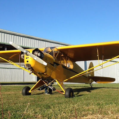
Finally taking Tyler up for some photos in the Cub

Plane: Cub, 85 hp 
Route: 40I, Local 
Weather: Clear, 77 degrees, wind 080 degrees at 4 knots

Such. Nice. Weather.

I really can't overstate how immensely beautiful the weather has been over the past week. And the current forecast shows roughly the same perfection for the next week. I always love September and October flying but this current spell has been downright amazing.

Long story short, I posted a message on Facebook a few days ago calling attention to this meteorological fact and asked anyone if they wanted to aviate this week. The first friend to take me up on the offer was Tyler; we've talked about going flying for what feels like forever but tonight was the first opportunity. Both he and I travel quite a bit for work and out schedules finally aligned.

I picked him up at home after work and we got to Stewart around 6:00. He snapped some photos as I did my preflight and pulled the airplane out of the hangar. Once everything was set, he climbed into the front seat, I into the back, and I taxied down to the west end of the field.

She's a good old bird - I have 56 hours (and counting!) in the 85 hp Cub

Checking the oil...

Out of the hangar and ready to take to the sky

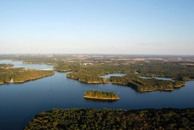
We took off on Runway 8 and I pointed the nose towards the lake. Visibility was as good as it's been lately; at less than 1,000 feet AGL both downtown Dayton and Cincinnati were easy to see on the horizon. We flew to the middle of the lake, then turned west towards Wright Brothers.

It was quite the night to fly over Caesar Creek Lake

Cubbin'

Tyler's clearly got a great eye - love this one

Tyler and his wife live near Wright Brothers; I checked for traffic then carefully circled overhead just east of the airport traffic pattern as he snapped some photos of their house. Aerial photo run complete, I headed towards downtown.

As we made our way north over the Great Miami River we were treated to an awesome sight. It seems the USAF pilots were also taking advantage of the nice weather to shoot some practice approaches at WPAFB. While circling around the city both a C-17 and a KC-135 flew directly over us, probably 500 to 1,000 feet above, on straight-in approaches to Runway 5L at KFFO. Another advantage of a Cub - the big skylight in roof that let us see both jets pass overhead.

Requisite flight over the front passenger's house

Downtown Dayton

Although we could have kept flying around taking photos for hours, the dwindling sunlight meant it was time to land. Tyler was up for a little fun, however, so I climbed up and did a couple steep turns and a power-off stall. Having enjoyed both, I finished with a steep spiral back down to pattern altitude. He was still grinning so it's clear we need to spend a little more time in the sky doing maneuvers - I may manage to convince someone else to start taking flying lessons before all's said and done here!

Cruising back to Stewart at about 2,500 feet

The very advanced Cub Tug™

Returning to the hangar after another great autumn evening flight

We came in to land behind one of the Champs, which took its sweet time to taxi off the runway. I could have easily landed safely but there's nothing wrong with a go around, so around we went as he cleared the runway. Within a couple minutes we were back on short final and I touched down rather softly and taxied back to the hangar.

Tyler had a blast. I'm glad we finally got in the air together and certainly hope to fly together again soon. Thanks to him for all the great photos in this post, too - it certainly never hurts to take a friendly professional photojournalist flying! :)

Flight Track: Google Earth KMZ File 
Today's Flight: 1.1 hours
Total Time: 342.6 hours

Sunday, September 20, 2015

Flying friends and a scenic flight over WMU before returning home

Plane: Cessna 172
Route: AZO-40I
Weather - AZO: Clear, 68 degrees, wind light and variable
Weather - 40I: Scattered clouds, 72 degrees, wind 080 degrees at 7 knots

After a great weekend in Kalamazoo - awesome friends and hosts in Jeff and Cassie, Shawarma, Sweetwater's, Arcadia, Bell's, Maggie's (stew!) and a WMU football win at Waldo Stadium - it was time to head home. But first we wanted to thank said hosts by treating them to a view of town from above. We left their house around noon to head to the airport; Duncan aviation had 14L parked out on the ramp when we arrived. I settled the fuel/hangar bill and did my preflight then we all climbed on board.

Jeff has flown in a small plane before, a long time ago with his grandpa I believe, and was excited. Cassie was slightly apprehensive. Both, however, were up for flying and all four of us climbed into the 172. We left all our bags in their car for weight and balance reasons. After checking the ATIS, calling clearance, and then being cleared to taxi by ground, we were rolling along Runway 17 for takeoff around 1pm.

I flew over campus, pointing out the familiar buildings, then continued north over their neighborhood; both spotted their house down below. We continued west over US-131 and WMU's engineering campus, home to Elson S. Floyd Hall, before Cassie was ready to land. I called Kalamazoo Approach and was cleared directly back to the airport. We landed 15-20 minutes after takeoff and taxied back to Duncan.

Another great trip where flying cut over half the time off driving

We thanked them again for their wonderful hospitality all weekend, grabbed our bags from the car, said goodbye, and loaded the plane up for the return trip. Engine running again, I contacted clearance and asked if we could fly north to circle over campus for photos before turning on course for Ohio; the controller kindly cleared us as requested. Again we taxied to the north end of Runway 17, I did a runup, and tower cleared us for takeoff.

Looking east over WMU's campus towards downtown Kalamazoo

The Seelye Center, Waldo Stadium, and Haymes Field

West Campus, WMU's main campus, from the south

West Campus, WMU's main campus, from the west

Looking across West Campus towards Waldo Stadium and East Campus

Western Heights, WMU's new residence halls, are in the left-center

WMU's massive new Valley Dining Center under construction

Downtown Kalamazoo with Gull Road stretching to the NE

The epicenter of downtown Kalamazoo

WMU's new Medical School in downtown Kalamazoo

Photo detour complete, I pointed the plane south and told the controller we were ready to proceed on course. Originally I planned to cruise at 3,500 feet but it was quite bumpy so I leveled at 5,500 instead. Compared to the marginal conditions of less than 48 hours prior, this afternoon's weather was damn near perfect. Everything smoothed out and we cruised along in relative quiet save for an occasional call over the radio.

Kalamazoo - Battle Creek International Airport (AZO)

Gina apparently wasn't very interested in the awesome views today

The rather new highway alignment of US-24 NE of Fort Wayne, IN

US-30, the historic Lincoln Highway, and the wind farm along the OH/IN border

Enroute we were passed from Kalamazoo Approach to Fort Wayne Approach to Columbus Approach. Until relatively close to Dayton the skies were completely clear and visibility was superb. ATC called out one traffic advisory north of Fort Wayne that I eventually spotted, a small plane in the pattern at De Kalb County Airport.

Grand Lake and Lakefield Airport (CQA)

Dayton International Airport (DAY)

Downtown Dayton, the Great Miami River, and WPAFB / USAFM 

A broken cloud layer developed close to home but it was at 6,000 feet and I was at 5,500 - just within VFR cloud separation requirements. This was important at that point as ATC instructed us to hold altitude until we were past the arrival and departure corridor at DAY. Soon after passing the big airport, the controller had me descend to 3,000 feet.

We were cut loose - radar services terminated, squawk VFR - about when we crossed I-675, or roughly 10 miles north of Stewart. The jump plane was occasionally dropping meat missiles and the Champ was in the pattern; I sequenced in amidst the usual controlled chaos. It was windy but right down the runway and I landed gently on Runway 08.

Total flight time, including circling for photos - two hours. Definitely beats the drive.

Skyhawks that smell like Sweetwater's are pretty sweet, too.

Flight Track: Google Earth KMZ File 
Today's Flight: 2.8 hours
Total Time: 341.5 hours

Friday, September 18, 2015

Negotiating marginal VFR enroute to Kalamazoo

Plane: Cessna 172
Route: 40I-AZO
Weather - 40I: Clear, 82 degrees, wind 160 degrees at 9 knots
Weather - AZO: Overcast, 74 degrees, wind 180 degrees at 5 knots

When it comes to flight planning, there are two sources of weather information I find invaluable. The first is NOAA's GFS MAV MOS graphics, which graphically depict what the weather models spit out of the supercomputers every 6 hours - the forecast visibility, ceiling height, and thunderstorm probability are particularly useful to me. The second is every local NWS office's Forecast Discussion, which is a rather technical discussion of what the meteorologists are interpreting from the current conditions and models, including a dedicated aviation section. Combined, they make it possible to watch trends develop and better understand the reasoning behind the simplified-for-public-consumption forecasts.

All week it was clear that rain and scattered thunderstorms were in tonight's forecast; the real uncertainty was whether a window with a clear path to Michigan would be open. At first it looked good, then mid-week it appeared to deteriorate. But this morning, after another detailed analysis of the graphics and discussions, it looked like it might just work out and I made the initial "go" call. A line of storms that moved through overnight was pushing east and the second wave and approaching cold front weren't expected to move into west Michigan until roughly 8pm. Visibility and ceilings would be approaching MVFR conditions along the final 1/3 of the route, but I'm familiar with the area and considered that acceptable for this flight.

Our friend Jeff, who we're staying with this weekend, planned on picking us up (thanks again!) and I sent him directions to our first, second, and third airport options. We originally were debating between Plainwell Municipal (61D) and Kalamazoo, as they live right in between. But I had already scratched Plainwell since the weather was likely to move in there first. So I sent him directions to pick us up not only at AZO, but also Three Rivers (HAI) and Battle Creek (BTL) since they are south and east, respectively - both good divert options if that became necessary.

I continued to closely monitor the weather at work and by lunchtime it was clear that a window still remained but we needed to be in the air by 5pm. Thankfully I was able to head out early, and left for home around 2:30. I quickly packed and got my final weather briefing in an hour; Gina met me at the house when she got off work and we headed straight to Stewart. She loaded the 172 while I organized the cockpit, fully fueled both tanks, and completed my preflight.

This quick video captured the conditions of today's flight's quite well

We took off about 4:55, right on schedule to beat the weather. I first leveled at 4,500 feet and contacted Columbus Approach for flight following up to KAZO. There was a broken cloud deck at 5,000 to 5,500 feet so that was the highest we could go. Based on the forecasts, I expected to have to descend to 3,500 or 2,500 as we approached Kalamazoo due to dropping ceilings. The PTT switch on my side was acting up and only transmitting intermittently so I swapped the plugs of my and Gina's headsets and used her PTT for the remainder of the flight.

Columbus handed us off to Fort Wayne Approach, which was nice - sometimes in that area you get handed off to Indy Center, and their radar coverage down low can be spotty. Soon after the handoff the clouds bases began to drop and I descended to 3,500 feet. Visibility was still around 10 miles and I was looking down upon many familiar roads and landmarks. Closer to Fort Wayne, I spotted an area of rain showers and decreased visibility to the northwest; the ceiling also decreased again slightly so I descended to 3,000 feet. At this point conditions were officially MVFR but I felt safe continuing, especially with many airports nearby. I also kept dialing in nearly every AWOS along our route to confirm conditions weren't deteriorating quicker than forecast.

We had to gradually descend while enroute to remain below the clouds

We passed through some of those rain showers over the final 30 minutes of our flight. At times visibility was definitely down near 5 miles, which I confirmed with AWOS broadcasts (though I think the lowest I heard over the radio was 6 or 7 miles) and a visual check of landmarks out the window and the GPS / sectional chart. Fort Wayne handed us off to Kalamazoo Approach roughly over top of US-20. Another plane that had just departed Angola to the east called in, also flying VFR to Kalamazoo. It's always nice to know someone else is up there with you!

I spotted Kalamazoo just over 7 miles out when the two familiar lakes south of the airport came into view. Traffic was light and I was cleared onto a long left downwind for Runway 17. Airport in sight, I descended from 3,000 down to pattern altitude, roughly 1,900 feet. The light wind was nearly directly on our nose and I touched down softly with the stall horn whining and a chirp of the mains on the runway. We turned off on Taxiway E and taxied to the FBO.

Radar after we arrived in Kalamazoo

Flight rules and radar shortly after our arrival

We slid in just before the front (and storms) moved through

A lineman marshalled us into a parking spot at Duncan Aviation. Fellow pilot friend and former Kalamazoo resident Chris loves the folks there and I agree - they do always take good care of us. Even when in a lowly rental, which doesn't class up the ramp nearly as nice as Warrior 481. Inside, I filled out a little paperwork and opted for their "Storm" option - they'd tie the plane down outside but move it into a hangar if they felt incoming weather was likely to damage the airplane. For $50. Better safe than sorry, though, right?

There's certainly a difference between flying over known, flat terrain with <3,000 foot ceilings and flying over unknown, slightly bumpier terrain with <3,000 foot ceilings. While I still think today's flight nearly pushed the envelope, I planned it extensively and had plenty of outs (i.e. airports to divert to) along the way. Then again, that trip to NY four years ago laid a solid foundation for decision-making that undoubtedly helped me with this flight. Just goes to show how pilots continually develop their skills and every flight, at least in some small part, adds to one's experience bucket.

Flight Track: Google Earth KMZ File 
Today's Flight: 2.0 hours
Total Time: 338.7 hours

Tuesday, September 15, 2015

Weeknight sightseeing with some coworkers in the Skyhawk

Plane: Cessna 172
Route: 40I, Local 
Weather: Clear, 75 degrees, wind 180 degrees at 6 knots

I convinced a few coworkers to go flying this evening. We're still in the midst of some great flying weather. Lorraine, Joe, and I have all chatted about flying in the past. She was on board first and convinced Joe at some point throughout the day. We left work and met at the airport around 5:30pm. Sidenote - I'm sure our boss is happy I didn't take out half the Kodak color science and workflow team with any stupid pilot tricks this evening. ;-)

Getting the trusty 172 ready

Explaining the trim wheel prior to taxiing

While preflighting the airplane we all chatted and I explained a few things and answered their questions. Then I got everyone situated and strapped in. Engine running, before takeoff checks completed, and everyone ready to fly, I departed to the west on Runway 26.

Pardon the long video, but I captured some great moments with tonight's cockpit POV!

View out the back just after takeoff

Passing over the fields on the west edge of the airport

We first flew north, passing over Centerville, Lorraine's house, and the new Costco development next to I-675 before passing over the office. Then we circled over Oakwood, the University of Dayton, and Joe's house. I looped around downtown Dayton then followed the Great Miami River south past Moraine Airpark.

Costco and a Kroger under construction in Centerville

The Greene in Beavercreek

Great Miami River and downtown Dayton

Carillon Park and the Deeds Carillon

I-75 construction downtown

The center of downtown with the Oregon District behind (in the top-left)

The new Water Street District under construction along the river

Fifth Third Field

Visibility was great; we spotted downtown Cincinnati from roughly 40 miles away. Joe caught sight of a combine plowing crops below and snapped a photo. I pointed out more sights near Miamisburg as we passed alongside some hot air balloons out sharing tonight's splendid conditions. As we passed the last balloon, I rocked the wings to say hello.

Cruising south above the Great Miami River

Downtown Miamisburg

We passed over this huge combine harvesting the fields

The farm was rather scenic from above in the lingering twilight

Most of the balloons we saw were down close to the farmland

This balloon was up much higher, between 2,500 and 3,000 feet

Continuing south we passed over Mason. Lorraine is seriously into tennis so I made sure to point out the  site of the Cincinnati Masters. Across I-71 from the Lindner Family Tennis Center is King's Island; we all enjoyed the view of the amusement park from above.

King's Island is a regular waypoint on my sightseeing tours

Before returning to Stewart I asked if they'd like to try some steeper turns. Both were up for the challenge so I banked over to the right then then reversed course and went back to the left. They thought it was fun so I descended in a steep spiral. I failed to remind Joe to look out the front during that final maneuver so he didn't feel 100% by the end, though he was still doing alright. I really felt bad about that; though they were both eager and willing for more than straight and level I certainly never intend to leave any passenger with a bad feeling in their stomach. Fortunately I was entering the pattern at that point and he was fine by the time we landed.

Entering the pattern to land back at Stewart


Everyone was grinning when I landed softly, directly into the blinding sunlight and approaching sunset. So I think it was another successful sightseeing flight despite a couple degrees of excessive bank. Lorraine and Joe both appear ready to fly again sometime and said they had a great time tonight, so that's all I can ask for. Taking people for their first flight in a small plane is still one of my most favorite piloting privledges, no question.

Thanks to Joe for nearly all the photos in this post, too!

Flight Track: Google Earth KMZ File 
Today's Flight: 1.1 hours
Total Time: 336.7 hours