Route: MGY-3G3-0GV-MGY
Weather: Clear to overcast, 65-85 degrees, wind 270-350 degrees at 5-15 knots
My friend Mike and I went up for yet another Pilots N Paws flight today. It was actually two flights - we had to cancel one on Friday due to thunderstorms. So this morning we launched on a somewhat crazy triangular double rescue flight from Dayton to Cleveland to Virginia and back to Dayton. The weather forecast just about everywhere was for clearing skies, the worst forecast being scattered at about 3,000 feet AGL by the time we arrived in the Cleveland area.
We took off from Wright Brothers shortly past 10 am into clear blue skies. Loaded in the back seat were two very large Collies that another pilot had flown to us earlier this morning. Less than 50 miles away the clouds had already started to go from scattered to broken and it was clear that the weather wasn't improving anywhere near as quickly as they had forecast.
Laurie and Billie on the ground at Wright Brothers

Wright State University, WPAFB, and the USAF Museum

The clouds started to close up as we headed north out of Dayton

Mike was able to get down below and we flew at about 2,000 feet MSL until close to Cleveland. It was obvious that the ceilings were continuing to drop so we diverted to Wadsworth, about 45 miles away from our intended destination of Lost Nation / Willoughby. The dogs' new owner had to drive down to meet us, which took about an hour and a half. We ate lunch and talked with some folks at the airport while the dogs lounged on the ground.
They're two very large and senior (10 and 11 years old) Collies

Relaxing on the ground in Mansfield

Happy to be heading home with their new owner!

Once the new owner arrived and we got the Laurie and Billy loaded into her car we headed back out to the airplane. It would be tight but the weather forecast to the south was for increasingly better conditions so Mike decided to head to Lee County, VA to pick up the next set of dogs. The visibility and cloud deck were both much better than when we had landed at Wadsworth as we climbed away on course.
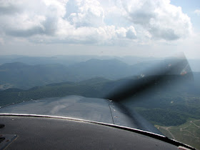
Again, that all changed as we got closer to our destination. Just past Huntington, WV the clouds dropped again and we had to descend to remain clear. Thankfully, things opened up again shortly and visibility improved. We had to divert around a small storm cell and there was a lot of haze, but the clouds were high enough that we were able to climb well clear of the rising terrain below. Once we cleared the last ridge, the clouds mostly dissipated and the ground dropped away steeply into the valley where Lee County Airport is located.
Again, the visibility and clouds looked pretty good at first...

Deviating around a storm cell

Getting hazier as we pressed on through WV towards VA

It's crazy how deep they cut into the mountains to build roads!

In between the clouds and terrain...

Crossing the final ridge before descending for arrival

Entering the pattern at Lee County Airport

We landed at 3:30 pm and did our best quick turn. Lee County is a strange airport, built about five years ago with a very nice runway and a beautiful terminal building - that sits empty and locked. The only thing available on the field is self-serve 100LL (for $4.24 a gallon - what a deal!) and a port-a-potty. Anyway, the couple that met us were very nice and Mike talked with them and loaded the dogs (three labs - two of which were young puppies) into the Skylane while I topped off our tanks.
The beautiful yet empty terminal building

Climbing back out over the ridge after picking up three Labs

Blackjack rode in the back seat - the puppies flew in a carrier in the cargo area

The weather again looked to be improving as we took off around 3:50 and headed back towards Dayton. In hindsight, we shoud've tried to climb above the clouds but we stayed below since the tops looked to be rather high. Visibility was again marginal at times and we had to change altitude to stay clear of the clouds. We had flight following the whole way home and ATC's radar was certainly a requirement as it would've been near-impossible to spot traffic at times. This was pretty much the way it went for the first 45 minutes of the flight home.
Another cell we had to avoid on the way from VA back to Dayton


Me and our happy backseat passenger

Near home the weather was absolutely perfect!

As suddenly as we ran into clouds on our initial departure earlier in the morning, we broke out into clear skies and unlimited visibility just after crossing the Ohio River. Nobody on the ground in Dayton would've ever believed our day of cruddy weather as it was in the low 70s and sunny all day at home. The last little bit of the flight went as the whole flight should have... if you had listened to the weather forecast. We rescued five dogs today but the most beneficial thing for us was getting a damn good reminder just how valuable an instrument rating can be!
Wow, 5 rescued...GREAT JOB!! Sounds like you guys had your hands full looking for traffic and making the on the go wx decisions. The IR really comes in handy and eliminates the pressure and stress of getting in or out of airports.
ReplyDeleteGreat shots of the storm cells, always good to give them plenty of space :)
Thanks, Gary! Most of the credit goes to Mike as it's his (club) airplane, money, and flying... but it's always fun to tag along and take a bunch of photos.
ReplyDelete